The proposed Pacheco alignment,
running along Henry Miller Road, will run right through
this kiosk at the Los Banos National Wildlife Area.
![]()
| There are currently two main alternatives to
bring the planned high speed railway from the Bay Area to the Central
Valley. Both have significant environmental impacts. The abandoned
Altamont Alternative has fewer, as it runs for much of its length along
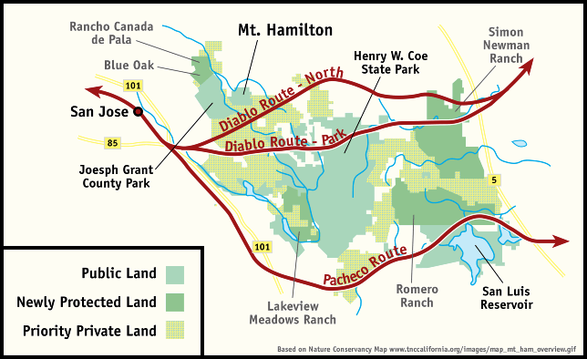
existing railway right of way or publically-owned corridors. The Diablo Alternatives propose creating a new transportation corridor between San Jose and the Central Valley (near the town of Patterson) through very challenging geography, bisecting a huge wilderness area and possibly Henry Coe State Park. The Pacheco Alternatives generally follow Highway 152 between Gilroy and the Central Valley (near Santa Nella), but also intrude on wilderness and parks. Additionally, these alternatives impose significant impacts on protected wetlands as the line crosses the Central Valley. "All three of the Diablo Range alternatives cross the Diablo Range Wildlife Preserve, which are considered conservation areas of importance.......the conservation lands could be considered a resource at a future date." The map below, adapted from the Mt. Hamilton map on the Nature Conservancy website, shows how each Southern Gateway alignment, Diablo or Pacheco, cross the wilderness areas.
Site discussing the issues of the wilderness area between Mt Hamilton and Pacheco Pass The Diablo Alternative has three variations:
The authority likes to promote the idea that they can eliminate wildlife impacts if they tunnel under the park or run to the north. This is a misconception. Under Construction.......
|

![]()